As early as 1975, the nature reserve at Kronören was created. In 1984, the area was expanded to include most of the peninsula and was then also supplemented with Drivören. The area's ora, fauna and geology have a great national value right here.
The southern tip of the Kronören peninsula, Långroudden, is one of the reserve's most distinctive parts. The tangible character of the exposed coast and drumlin landscape is very clear. Wind, waves, ice blasting, ice screwing and even the mighty forces of the ice sheet have created both cobblestone fields and bare-washed rocks. On the cliffs there are ice reefs and water-filled boulders and on the cobblestone fields you can find remnants of simple and temporary dwellings that previous generations used.
Those interested in geology can also study the slippery gneiss of the rocks, which is pierced by light and dark bands of other rocks.
The hiking trail at Långroudden
In the outermost band, a vast cobblestone field spreads out over the area and contains a variety of exciting relics and plants. A paved path takes the visitor to a number of ancient monuments, including elves, a maze and a compass rose.
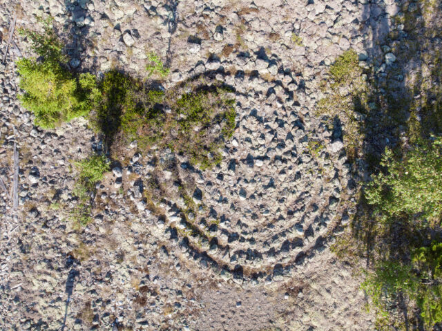
The landmarks are remnants of salesmen and landowners in the 16th century. The paved trail runs in a loop around the headland and is equipped with information boards along the road. Further out on the headland, the barrenness becomes increasingly apparent. Here, plenty of sea buckthorn grows in its places and in the autumn the fiery yellow berries glow in the barren surroundings. Despite the vulnerability, there is a richly flowering beach meadow in one of the protected bays, with an abundant presence of beach veronica and beach asters.
The birdwatchers also usually go to Långroudden during spring, autumn and winter because the cape is with them. Exposed location often offers good opportunities to see stretching or stationary seabirds. When the ice is off the coast of Umeå and all the trout, swans and ducks are blown away from the quiet winter landscape, Långroudden is usually a good alternative for those seeking ornithological experiences by the sea. Here the ice rarely settles.
Kronören is also a classic sea eagle land. One of the first couples to establish themselves in Västerbotten – Ångermanland in the 1970s after the species has been extinct for a few decades, built its nest in Kronörens gammelskogar. Today, there are still a lot of them both inside and outside the nature reserve.
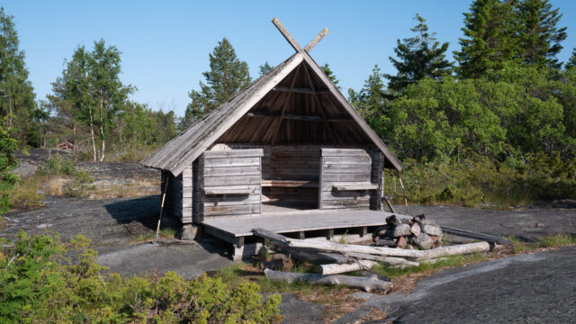
Hike to Godhamn and Vedhällan
Another marked and easy hike within the reserve begins at the large parking lot a few kilometers before the end of the road. The trail runs through forest and rocky terrain and close to bird-rich beaches. Johan Elmberg writes in the book "Birds in Nordmaling and Bjurholm" that "Kronören is one of the few places in Sweden where you can see more than 100 bird species on foot in one morning". Both sea eagles and ospreys nest in the area.
The hiking trail largely follows an old forest path to Godhamn, a fi ski resort that was in use into the 20th century. The crowds moved there with families during the summers while the herring hunt took place. Katarina Sörlin tells about how her father Kalle Öberg and her grandparents moved to the ski huts in the summers to do things. The families brought a cow or a goat with them and lived in simple "kitchens". The rules for this were strict, no one e.g. leave Godhamn to lay out their attendants before a certain time.
The only known habitat for the Arctic ponytail
The crown tube is also unique in another sense. Here fi nns, as Stefan Ericsson writes in his article, today the only known Swedish plant plastic for the Arctic horsetail (Hippuris tetraphylla). It is a beach plant that previously also grew in the Västerbotten Sladan nature reserve. The Arctic horse tail, which grows like an upright tail in the shallow water off the shore, is found in the bay between Storsandskäret and the mainland.